
Here are some pictures and video we took when Mike, Alex, and I hiked
the Crystal Pass Traverse near Mt. Constance... This was a wonderful
traverse, especially since we didn't have to descend the f-ing Constance Creek
Trail... Started out Thursday evening, getting to the trailhead, excuse me,
washout around 6:30... 3 and a half miles up the road to the Constance Creek
trailhead, and then up about a thousand feet... I was getting tired, it was
getting dark, so we camped in one of the few flat spots on the trail. On Friday,
up at 5, and out by a little after 6, we made the lake by around 8. The trail
was in pretty good shape, no snow until the lake. After a rest, we headed up
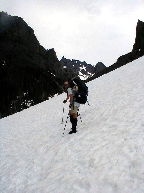
Avalanche Canyon on terrific snow. Thankfully, the weather was semi-overcast
with spot showers, otherwise it would have been baking!
We stopped for a bit to decide on which pass shelf to go to, and decided on the
one on the left. Scrambling opportunities looked the best there with Desperation
right there. We made the pass (6500 feet) about 1, set up camp, and just napped
and baked in the now clear skies. The views of Constance, Inner Constance and
Warrior are great. After dinner, Mike and I scrambled Desperation, and then
scouted a place to watch the sunset. From the top of Desperation, the views
extended deep into the southern Olympics to Brothers, Pershing, and to the west
for the Gray Wolfs and Needles. After sunset, a dicy decent under headlamp, and
some great sleep - no wind, and beautiful night skies.
A lazy morning on Saturday, and we broke camp around 8:30 to head over to an
alternate pass to drop down to the southwest of Warrior. We made this pass (6800
feet) around 9:30, and hung around to let the snow soften a bit for the steep
decent. In the meantime, we were entertained by a two person team climbing
Constance on route 1A. Roped, the leader looked pretty comfortable, the person
on trail looked less... Having climbed Constance on this route a couple years
ago - it's a wonderful approach, but a bit exposed for the squeamish. It was
still in pretty good shape, just starting to open up in a couple places. After
they made the notch, a little after 10, we decided to head down to the Warrior
approach.
Once down, we spot a shelf to the west, on the far north side of the Inner
Constance arm, and decide, what the hell, that looks cool. So we head over
there, and have camp set up by 1 again. We're about 500 feet below the wall we
watched the sunset the night prior, and about 1,000 feet directly above the Home
Lake valley. To play, we found a 30 foot snow wall where the upper 15 feet was
vertical, and the bottom gradually rolled flat. So now it's an ice climbing
contest with standard ice axes and boots! Then we turned our attention to some
chutes, and had standing glissade contests (I suck)!
The next day, we pondered Warrior, but decided to just head out. Down the
standard approach, and then wrapping north around the west side of Warrior, we
dropped down and met the Home Lake trail a couple miles from Boulder Shelter.
The trail was mostly clear here, but still covered with snow towards Constance
Pass. After a break at Boulder Shelter, a leisurely stroll out the Dungeness and
we're done...
Click this link to view a profile of the trail on a topographic map. Click on the thumbnails in order to view the pictures full size. The video is in Windows Media for Video (WMV), click here if you need to download the viewer...
| The hike in... - Normally, the drill is to check in at the ranger station for back country permits, and then come back a mile or so to the Constance Creek trailhead to Lake Constance. But during this winter, a big chunk of the road was washed away by the Dosewallips River, more than 4 miles from the ranger station (3 from the trailhead). There is a detour around the slide, and then hike the road, past the ONP entrance, up to the trailhead. It's pretty strange hiking the rest of the road, which is in great shape, except for the occasional blow-down. Once on the real trail, it heads up - fast, I tired pretty quickly. I gave weight to Mike and Alex, but after about a thousand feet of gain, I told them we needed to set up camp. |
|
||||||||||||
| Getting up... - Setting the alarm for 5 am, we managed to be up, moving and packed by 6. Come to find out, Mike would have preferred to sleep in a bit. But once everyone was moving, he quickly joined the program... But by getting an early start, he was able to explore features along the trail, we would have passed by if we headlamped the previous evening. About half way up the trail, a huge rock sits amongst the forest. And the trail next to the creek is very scenic, as Mike pauses on a log straddling the creek. | |||||||||||||
| Constance Creek Trail... - This trail is relentless as a quickly climbs to the lake. The first 3/4 mile is very steep. After a very brief respite, the trail again steepens to gain the lake. This is a great trail with day packs, and a big pain with overnight climbing packs. None the less, by stopping after the first thousand feet of elevation gain, and past the steepest section, the rest of the trail wasn't bad. There are still some sections that appear ridiculous though. Here, Alex makes his way under a tree, and then ponders another section of trail! |
|
||||||||||||
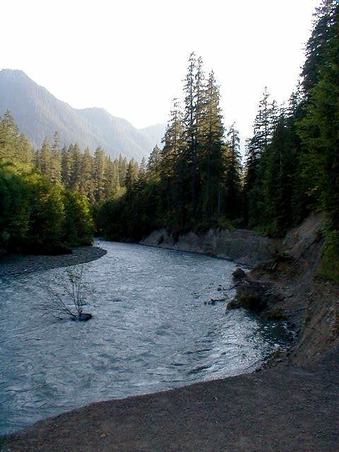
| Lake Constance... - Once at the lake, we're only a couple miles and 2,000 feet from our objective for the day - which is the camp site for Crystal Pass - and it's barely 8 in the morning! So we find a nice peaceful area, and relax for a while. Some clouds have moved in, dropping light showers, so we took some shelter under some trees. Here Alex catches Mike in a quick snooze, while I sit back and take it easy. |
|
||||||||||||
| Avalanche Canyon... - Once the showers subsided, we headed up Avalanche Canyon towards the day's goal. This panoramic shot was taken by Alex, and includes the fingers heading up to Inner Constance on the left, and the chutes heading up to Constance proper on the right. Crystal Pass is in the center... Note the clouds - it was suppose to be clear and hot! Thankfully, after some minor spitting, these burned off after we made the pass. Alex took this shot of Mike and I as we headed up the canyon from Lake Constance... Mike then took this shot looking back toward the lake... | |||||||||||||
| Mike's cave... - About half way up the canyon, Mike came across a small cave - which he immediately dove in to. Here is the view Mike had of unsuspecting passers-by. Click on the video link under the thumbnail in order to get a narrated tour. Once out of the cave, Mike then proceeds to scramble a nearby boulder and strikes a GQ pose (video - 1.8 meg). Alex and I weren't very impressed... | |||||||||||||
| The West Rim... - Further up the canyon, a huge basalt headwall defines the west rim. Noting the photographic opportunity, Mike rushed over for pictures. This chunk of rock defines the makeup of the Olympic Mountains - pillow lava that resided on the bottom of the nearby Pacific Ocean around 10 million years ago. While photogenic, it's hideous to climb with it's flaky, downward sloping rock. Mostly good feet, but no hands at all! Mike shot a different view, and catches this awesome picture of the wall and the summit of Mt. Constance... Mike also took this shot of Alex in the distance making his way up the canyon. |
|
||||||||||||
| Under wraps... - Further up the canyon, some more clouds moved in, and it started to rain. We quickly threw a tarp over some rocks and crawled under to wait it out. While underneath, Mike shot this video (2.5 meg), as we philosophically discuss the weather. The pictures are captured from the video... |
|
||||||||||||
| Saddleback Park... - Once the weather cleared, we made the pass in about an hour. We had a short discussion about which saddle to go for, as there are two. We chose the one on the left (west) since it was adjacent to Desperation, which we figured would provide the evening's entertainment. Mike made this taped tour (7.5 meg) of the views and amenities available at our deluxe accommodations. Mike also took this nice shot of Avalanche Canyon looking back to Lake Constance from the pass... |
|
||||||||||||
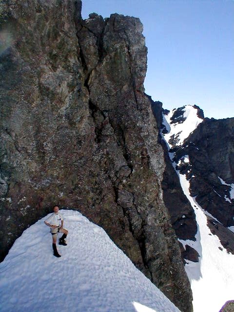
| An evening on the rocks... - After some afternoon snoozing, and a warm dinner, Mike talks me into heading up Desperation, and then over to find a good spot for sunset. The weather is perfect now, with no wind, clear skies and temperatures in the 60s. The scramble up is generally 4th class over sketchy talus and loose basalt. Mike didn't like it too much, primarily because of the down climb. I was less apprehensive, and making the scramble pretty easily. I took this shot about half way up the slope. Once on the ridge, I took this shot of Mike with the canyon in the background. The exposure on this scramble is exquisite, much like Black Peak in the North Cascades... |
|
||||||||||||
| Summiting Desperation... - The scramble along the ridge quickly leads to a false summit. Along the way, Mike shot this video looking back down the canyon (2.2 meg). To make the real summit, traverse a notch, and then scramble the remaining 20 feet to the true summit. Mike shot this video of the occasion (5.2 meg). |
|
||||||||||||
| Route finding... - Following the summit exercise, we headed over to the top of a wall that overlooked Warrior basin and the Home Lake valley for the sunset. Mike hauled up at least 20 pounds of camera gear, and was determined to use it! He wouldn't be disappointed on this evening with the sunset very dramatic with excellent clouds for texture. The other reason for moving around is to check a possible route that will allow us to more easily get over in to the Warrior basin. We find a high pass with good, but steep snow. Mike and I discuss it in depth (3.3 meg). I agree it will be easier than the documented route which would have us move north towards Warrior Arm. Mike took this great black and white shot of the chute. |
|
||||||||||||
| The death chute... - A lazy morning on Saturday, and we're pack and heading out around 8:30 for the Death Chute! Actually, this turned out to be some great route finding by Mike as it allowed a direct passage to the good Warrior approach. The snow was about as perfect as it could be made without crampons (although we had them), and we made the saddle quickly. Here, Alex puts in the last 20 or so steps to the saddle. The back side wasn't quite as steep as it looked from above, and if we waited for the sun to come over, the plunge steps would be fine without roping up. Alex took this shot of Mike and I... In the meantime, we were entertained by a couple climbers over on the Constance 1A chute, which I taped (3 meg). Alex also took this picture of Mike with the Constance chute in the background... As we headed down, Mike took this shot of Alex and I with Warrior proudly in the background... | |||||||||||||
| Spring time playground... - Once down from the saddle, we found several features on which to entertain ourselves! The first was a snow bank that was back from the rocks, about 30 feet high, with the upper 15 feet vertical, and the bottom gently rolling flat. Mike tried a section, but found the placement sketchy about 5 feet from the top. I tried a different section that was a bit easier, which Mike taped (8.2 meg). Flush with my success, I tried the route attempted earlier by Mike, but found the same problem. Bailing on that route, I moved over, and tried a different route, which Mike also taped (7.8 meg), and where during a move, my placements totally failed! |
|
||||||||||||
| Another camp in the sun... - After playing on the snow wall, we look around, and found this great saddle overlooking the Home Lake valley, with the Needles range in the background to the west, Warrior directly overhead to the north, and the Inner Constance system directly to the south. Deciding this perch was much better than the one we were going to go for near Boulder Shelter, we quickly make camp, and again it's a lazy day. I taped this scene of the camp site (5.6 meg), along with a unique fluid capture system! |
|
||||||||||||
| The master glissader... - After some frisbee, local glissading, general touring, and dinner, Mike decides to try a lengthy standing glissade of one of the nearby chutes. To his credit, he does a great job, even kicking up a nice wake, until a hidden rock changes his plans! Of course, I have it on tape (2.8 meg). Mike took this shot as I feebly tried to match his feat. |
|
||||||||||||
| Waiting for sunset... - As the sunset approached, it was apparent it wouldn't be as good as the previous evening. None the less, we waited patiently as I shot this video (4.9 meg), and discussed the role of signal processing in photography... As the sun receded, Mike took this shot of Alex and myself with Warrior as the backdrop... As the glow grew soft on Warrior, Mike snapped this panoramic view of the twin peaks... |
|
||||||||||||
Heading
out... - Up
at around 7, we took our time packing to head out as the
pick-up wasn't until 3 that afternoon. After some
discussion, we decided to try to get the pick-up sooner, so
Mike was going to hike up to Charlia Pass while Alex and I
went to Boulder Shelter. From the pass, he could call
Denise to arrange for an earlier pick-up. At the spot
where we joined the Home Lake trail to get to Boulder Shelter,
Alex took this shot looking back up to our camp site.
Other shots include:
|
|


